


News
« Return to News4 May 2018
Fish and Sediment Monitoring at the Derwent Reservoir
Seven Trent Water own and operate three reservoirs in the upper Derwent valley: Howden, Derwent and Ladybower. These provide water to Bamford water treatment works from where it is distributed to a large number of Seven Trent’s customers. The Derwent valley, its surrounding woodlands and moorlands are very popular with visitors, many coming from nearby Sheffield.
As part of Seven Trent’s goal to generate 50% of its energy needs through renewable technologies by 2020, the decision was taken to construct a hydro turbine and utilise the energy available from the 27m head difference between Howden and Derwent reservoirs to generate up to 300kW of electricity. The turbine was constructed near the mouth of Abbey Brook. Water from the turbine is discharged into a concrete spillway before passing over stone rip-rap.
 The Environment Agency (EA) gave authorisation to abstract water for the scheme and in granting the licence, set out a number of conditions to address two concerns: the possible adverse impact on fish and the mobilisation of sediment in the basin where water is discharged.
There are established populations of brown trout in Derwent and Howden reservoirs and the EA’s concern for these was twofold. Firstly, the fish in Derwent could be drawn towards the discharge from the turbine, rather than Abbey Brook, when spawning. Secondly, fish could be drawn into the outlet pipe from Howden Reservoir.
The EA was further concerned that the turbine discharge could disturb sediment on the bed of Derwent reservoir, particularly at low water levels. The worry was that fine sediment could smother the river bed, filling spaces between the streambed material and adversely affect macroinvertebrates and compromise fish spawning grounds.
PAA was commissioned by Wardell Armstrong on behalf of Severn Trent to work with the Environment Agency to help design and put in place monitoring arrangements to check that fish were coming to no harm and that sediment was not being mobilised.
Fish Monitoring
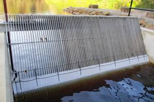
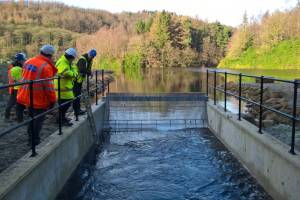 A stainless steel 25mm screen has been installed at the end of the spillway. This is in part to prevent trout swimming up the spillway towards the turbine as their natural instinct is to swim upstream. Fish monitoring is undertaken systematically by covering the screen with a 2mm mesh. The turbine is shut down while the mesh is being fixed then run again for about three hours, controlling the flow to create a variety of discharge conditions. The mesh is then checked for any material that has been caught.
 In what is thought to be an unlikely event, if fish have been entrained by the turbine there may be few remains available for easy identification. It is possible, however, to identify fish to species level by examining their scales, which grow as the fish ages by adding hard tissue to their edges. This creates a pattern of concentric circles, or circuli, on each scale. Samples of material caught on the screen are collected and microscopically examined in the PAA laboratory for the presence of scales.
The scheme became operational in December 2017 after a period of initial trials earlier in the year. Monitoring has only recently begun but to date, no fish remains have been detected.
Geomorphological Monitoring
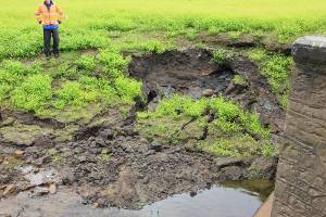
The water level in the basin is controlled by the water level in the Derwent Reservoir. The potential for erosion and sediment entrainment is increased when the water levels are low, when Abbey Brook is confined to a more defined channel and water from the scheme flows over the accumulated sediments in the basin before entering the brook. 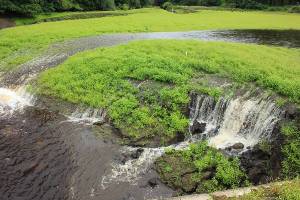
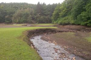 If the basin is full, up to the level of the riprap, the turbine is operated but if the level falls and the basin sediments are exposed the turbine is automatically closed down. In this way the turbine discharge is only released into ponded water, which quickly reduces the water velocity and erosive potential.
To monitor any sediment movement, characteristics and morphological changes in the basin a fixed point photographic survey has been introduced. Graduated gauge boards have been installed in the basin and brook to provide a permanent structure against which any changes can be measured, e.g. erosion and reduction in sediments that exposes more of the gauge, while an accumulation of sediments is registered if the gauges are buried. Obviously, monitoring any morphological change can only take place when the sediments are exposed.
Monitoring is to continue over two years but so far no evidence of fish mortality has been detected and establishing a discharge regime that only permits water release when reservoir levels are high has prevented any detectable mobilisation of sediment.
We are delighted to have been involved in this project and look forward to continuing to monitor over the next two years.