

GIS and Digital Mapping
Penny Anderson Associates Ltd. (PAA) make excellent use of Geographic Information Systems (GIS) and geo-technologies to aid our work and improve our understanding of environmental issues. Using advanced GIS technology our experienced, professional team can collect, manage and analyse complex spatial data to improve your understanding of environmental phenomena.
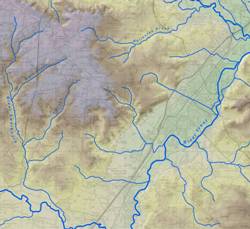 We pride ourselves on the high quality of our products and solutions, including geospatial data capture, geodatabase construction, data analysis, digital cartography and the production of high quality mapping, principally in the fields of spatial analysis, multi-criteria evaluation, field-based GIS, GPS survey and ground modelling and volumetrics.
Vegetation Mapping
Our unrivalled combination of botanical surveyors and GIS analysts enables us to provide accurate, in-depth mapping of habitats and, through comparison with historical data, landuse change. The use of geo-referenced, remotely sensed images increases the reliability and functionality of our mapping products.
High Accuracy GPS Survey
GPS is an extremely useful tool for providing accurate real-time location data, for use in both navigation and survey. PAA can provide a complete, sub-metre differential GPS solution for your mapping project.
Remote Sensing Interpretation and Analysis
Remotely sensed imagery is used widely in many fields to provide context and perspective. At PAA, we have the expertise to extract information from many types of imagery (for example aerial photography and multi-spectral satellite images). With improvements in spatial & spectral image resolution, there is increasing potential to produce effective products using innovative analysis techniques, software and our expertise.
 Bespoke Mapping
If you have specific cartographic requirements, we can meet these through our bespoke mapping service. Ranging from using a client’s own drawing frame to direct control over the visual output of mapping, we can provide the experience and skills necessary to give you a clear and professional cartographic product.
Data Migration and Integration
PAA can use GIS to integrate a wide variety of data into your project, enabling you to expand your vision and enhance your understanding. Our experience in assimilating data for a number of projects gives us a sound knowledge of the many data sources available, including base mapping and topographical data, environmental and hydrological data and sources for remotely sensed imagery and administrative boundaries.
Field-Based GIS
Using our mobile GIS units and software, PAA has the capability to collect data directly in the field. This improves accuracy, enables the surveyor to check records during the survey, and removes the lengthy in-house digitising re-capture and verification process.
Geodatabase Construction
Many organisations are currently involved in the production of databases which hold their key spatial datasets. These ‘geodatabases’ may include Ordnance Survey base mapping, aerial photography, satellite imagery, CAD drawings as well as a broad spectrum of environmental datasets such as soil, geology, habitat and species information. PAA has extensive experience in geodatabase development, starting with providing initial advice on user requirements, to capturing diverse spatial datasets using a variety of techniques, and ending with the efficient delivery of the final data product.
Landscape Evaluation
GIS is a powerful tool when used to combine many data sets and analysis methods and, as such, can provide an excellent insight into landscape-scale features and processes. PAA can help you to achieve these insights, and can provide a tangible, working product, which can then either be used as a baseline for further study, to prioritise future work, or as an end product in itself.
For more details on our services relating to GIS, please contact us